
Alta Marca Trevigiana
The geographical area called the Alta Marca Trevigiana includes the areas of the Quartier del Piave and Vallata. Great tourist interest's area, we find here in the abbeys, in the sanctuaries and in the parish churches scattered almost everywhere, and in the oratories of the countryside or hills, often ancient, testimonies of faith and religious culture.
The profile of the Dolomites stands out clearly on the landscape that opens onto mountains and hills, where the excellent Prosecco DOC wine is produced, and on the plain below. The mountain huts, the point of arrival on foot or by car or starting point for many excursions, are an irreplaceable point of reference for those who love the mountains.
It is crossed transversely by the Prosecco Wine Route, the pride of the region.
Staying in these places you will discover a remarkable heritage: from the Molinetto della Croda to Refrontolo, to the Caves of Caglieron in Fregona, from the Abbey of Cistercian monks in Follina to the Abbey of Santa Bona in Vidor, the Castle of San Salvatore in Susegana , the Towers of Credazzo in Farra di Soligo, the "Isola dei Morti" in Moriago della Battaglia...
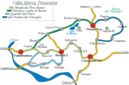
The zone
Here the paths, on foot or by bike, in the amphitheater of vine cultivation, are the same used by farmers to cultivate the vine, and climb the hills through valleys, springs, farmhouses, churches and medieval towers, the views range from Venetian lagoon to the Dolomites. Getting lost is impossible, all the paths are connected to each other, the visual reference for the return are the Towers of Credazzo or the Church of Farra.
When
Here the winters are mild, and in the hot summers a light breeze, in the shade of a fragrant fig, means that the holiday is like a king. Every season has its own suggestion, the five senses, put to the test by modern life here reconcile with the mind, with your eyes closed you can walk and see what surrounds you.
How
There are 6 paths of Farra di Soligo; all are connected to each other, however, to access the paths n ° 4.5, or 6, you must start from the paths n ° 1, 2 or 3, and the departure is from the city center, and precisely the n ° 1 from the Elementary Schools , in ° 2 from the Canonica, and n ° 3 from the Ex Cantine Carregiani.
Below, we have briefly described the paths, even without a map you can practice them, along the way you will surely find the information you need. Guided tour are available with reservation.
Path n° 1 - Sentiero delle Crepe - Length: 2,5 km - Difference in height: 160 mt
Stages: Scuole di Farra - Strada Fiorentina - Pianesei (Porchera) - Case Viani - Le Crepe - Caberlata - Villa Adorna - Forcella di San Martino.
The toponym "Crepe" derives from the numerous landslides and fissures in the ground. The path climbs up the hills characterized by vineyards and numerous cottages, the first part follows a cemented road; at the end it is possible to visit the Sanctuary of Collagù (detour on n ° 6)
Description: The path starts from the city center of Farra di Soligo, near the Elementary Schools, at the end of Via Aldo Moro you immediately climb towards the south side of the hills characterized by the vineyards.
Path n° 2 - Le Costalliere - Length: 2,5 km - Difference in height: 180 mt
Stages: Municipio Vecchio - Borgo Grotta (Costalliere) - Culaf - Case dela Favera - Col Vinal (q. 380) - Forcella Colesie.
The term, "Le Costalliere", derives from the term "castelliere", that is a settlement of the Bronze Age, prevalently pastoral character with dry stone fence, all this is attested by archaeological finds. The trail immediately goes into a valley, then climbs up the hills characterized by vineyards and numerous rustic, sometimes along unpaved roads, cemented in the steepest parts.
Description: The trail starts from the city center of Farra di Soligo, after the church towards Col San Martino (West), at the second street, near the road that leads to Sernaglia on the left, turn right in via Rialto; this goes into the valley of the Rio Farra through the village Grotta.
Path n° 3 - Gor della Cuna - Length 3 km - Difference in height: 260 mt
Stages: San Giorgio - Ex Cantine Careggiani - Costa Fontanella - Gor della Cuna - Case Berton - Zulle - Vanal - Col Moro - Forcella Xocco.
The toponym "Gor" means a spring, while "Cuna" indicates the cradle of the newborn, therefore a "source in a valley". The first part of the trail is almost flat, then goes into a shady valley, and finally climbs up the hills characterized by vineyards and numerous rustics; sometimes it runs along unpaved roads, cemented in the steeper sections.
Description: The trail starts at the end of the city center of Farra di Soligo, on the road that leads to Col San Martino (west), turn right into via S.Nicolo, the path runs through the Rio valley Zullo; beyond the hill, on the left, you can see the hill of the Towers of Credazzo and the church of San Lorenzo.
At the end of the path, you can practice paths n ° 4 or 5 or 6, through these you can return to the city center along the three main trails, 1-2-3
The paths n ° 4/5/6 are panoramic, from there it is possible to see the Piave valley to the south or the Vallata and the Treviso pre-Alps to the north.
The paths n ° 4/5/6 cross the top of the hills, with a quota ranging from 320 to 470 meters.
n°4 - Alpine Path - View on the pre-Alps
Stages of the route: Monte Pertegar - Forcella Xocco - Pian Serafin - Forcella Colesie - Colesie/Col Vianl (q. 450) - Forcella di S. Martino
Time:1,30 hours - Length: 2,5 km - Difference in height: max 100 mt
n°5 - North Path - Overview towards Campea
Stages of the route: Forcella Xocco - Col Piero - Forcella Colesie - Val Scura - Bosco Faghere (a sx bivio per Campea) - Parafitte (a sx bivio per Campea) - Fontana Fredda - Villa Adorna
Time: 1,30 hours - Length: 2,5 km - Difference in height: max 100 mt
n°6 - South Path - Panoramic on the Quartier del Piave
Stages of the route: Ai Pertegar - Forcella Xocco - Casete Dale - Monte Baldachin - Forcella Colesie - Cargnele - Forcella di San Martino - Villa Adorna - Santuario del Collagù
Time: 2 hours - Length: 3 km - Difference in height: max 100 mt